Usk
Land Survey
3D Laser Scanning


3D Laser Scanning
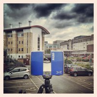
3D laser scanning is a very powerful survey technique for data capture due to the speed of data collection and the highly detailed data sets obtained, and lends itself to many engineering surveying applications. Short, medium and long range scanners can provide non contact measurements to well defined features with a repeatability as low as +-5mm and can also provide spatially referenced digital photography.
The benefits afforded by laser scanning include: rapid data capture for large area coverage and areas of restricted access, H&S benefits from remote/non-contact data capture, comprehensive data sets containing millions of points of detail and flexible data extraction & delivery options.
Deliverables can be tailored to the needs of the client, and include pointcloud data, 2D & 3D CAD linework and 3D modelling.
•3D Models
•Visualisation
•2D Floor plans
•Elevations
•Sections
Usk Land Survey © 2015
8901 Marmora Road, Glasgow D04 89GR
Copyright @ All Rights Reserved